John J Czaplewski

Mapper | Software Engineer

Projects

fallline.io

Classification and stats for your day skiing

Gaia GPS Map

Best-in-class backcountry trip planning (part of development team)

balmy.us

An experiment in using weather.gov's APIs

Rockd (iOS and Android)

Learn, explore, and record observations of your geologic world

Rockd (Web app)

Desktop exploratory interface for Rockd

Rockd.org

Promotional website for Rockd

GeoDeepDive.org

Project website for GeoDeepDive

Burwell

Mobile-friendly geologic maps

Sift

Explore the Macrostrat database

Macrostrat.org

Homepage for the Macrostrat Lab @ UW-Madison

Macrostrat API

An API to enable science

busMSN

Bookmarkable, location aware live arrival times

Team USA - Sochi

Mapping the winter athletes of Sochi 2014

Macrostratigraphy Map

Visualizing stratigraphy over space and time

Paleobiodb.org

Gateway to the Paleobiology Database

Hubby & Yummy

A ridiculous exercise in recipe comment analysis

Adaptive Composite Map

An implementation of the adaptive composite map project in D3.js

Michigan Basin Fossils

Photo catalog for Friend's of the Michigan Museum of Paleontology

Webmap template (EIA)

Webmap template created for Mid America Freight Coalition

Webmap template (Corridors)

Webmap template created for Mid America Freight Coalition

Ecycle locations

I couldn't figure out where to recycle electronics, so I made a map

Freight corridors

A subway-style map of freight corridors in the Mid America Freight Coalition

Pronounce Wisconsin

Interactive pronunciation gazetteer of Wisconsin placenames

DLCCC 2012

A map of routes climbed during the Devil's Lake Century Climbing Challenge

Frac Sands

Following the expansion of frac sand mining in Chippewa County, WI

Policy Homogenization

Visual argument for homogenizing freight policy in the midwest

Renewable Energy

First map with D3.js. Learned and created in 40 hours.

Team USA - London

Mapping Team USA in the 2012 London Olympics

CashFree

My credit union didn't have an ATM finder. But they had locations...

Federal Spending

Data viz exercise. Found a news article, made an accompanying visualization.

Hoofermountaineering.org

A website for Hoofer Mountaineering Club at the University of Wisconsin

John Muir Trail

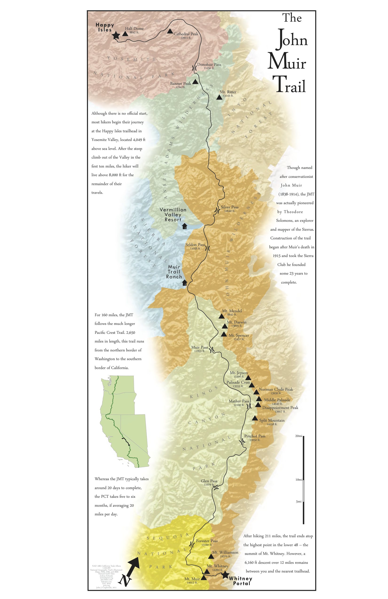
Print map of the John Muir trail

Devil's Lake Bouldering

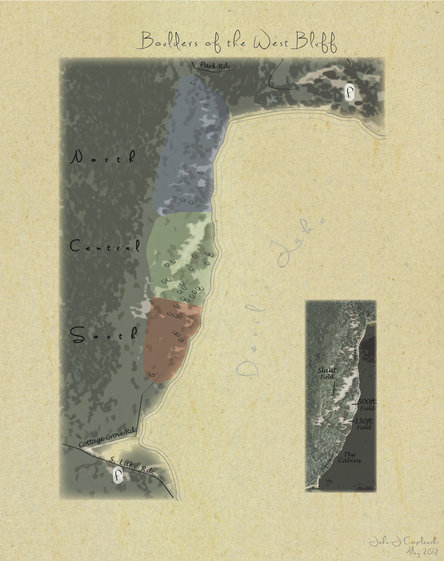
Print map of bouldering on the west bluff of Devil's Lake

Political Europe

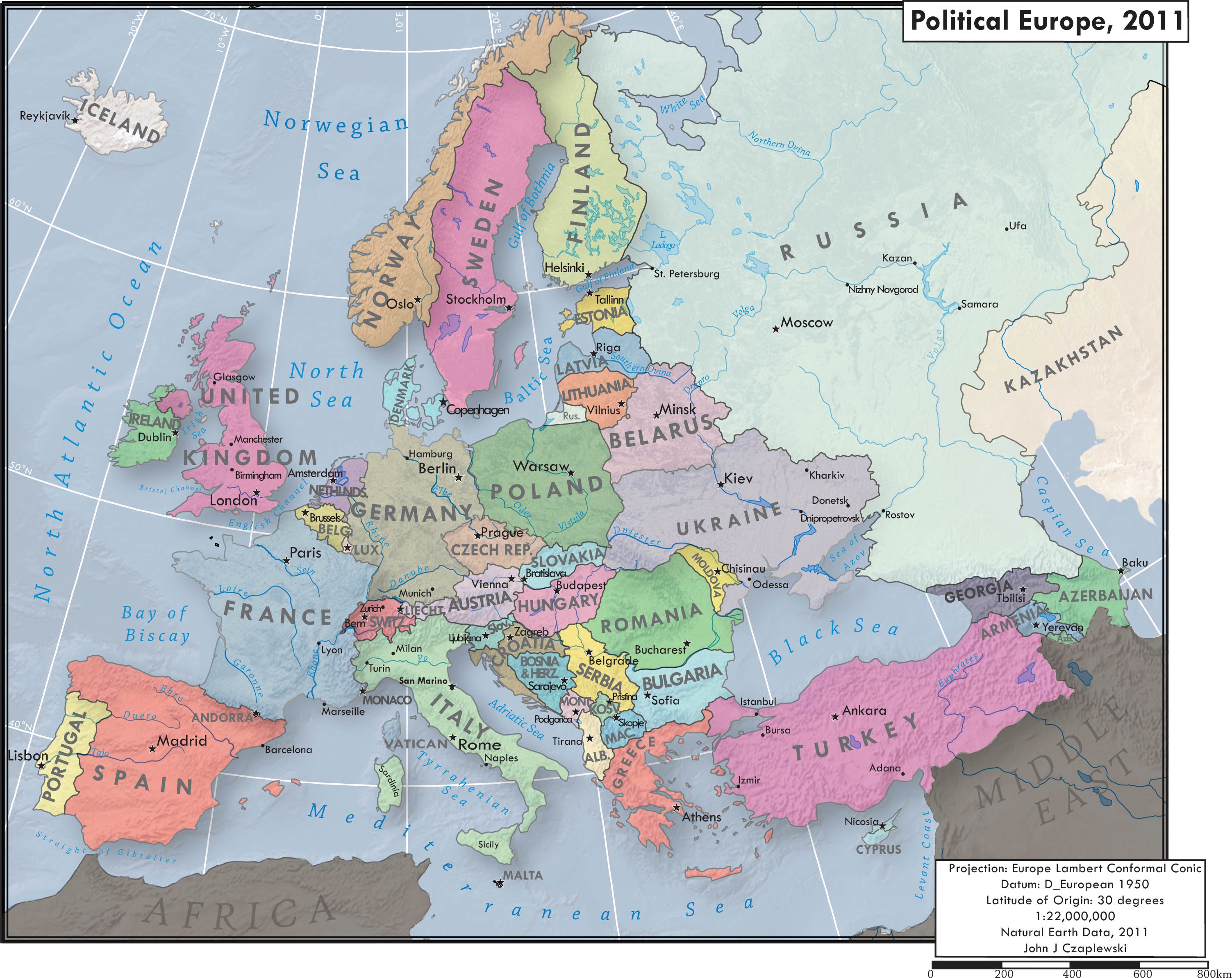
Print map of Europe. Lab assignment in label placement.

Obesity Epidemic

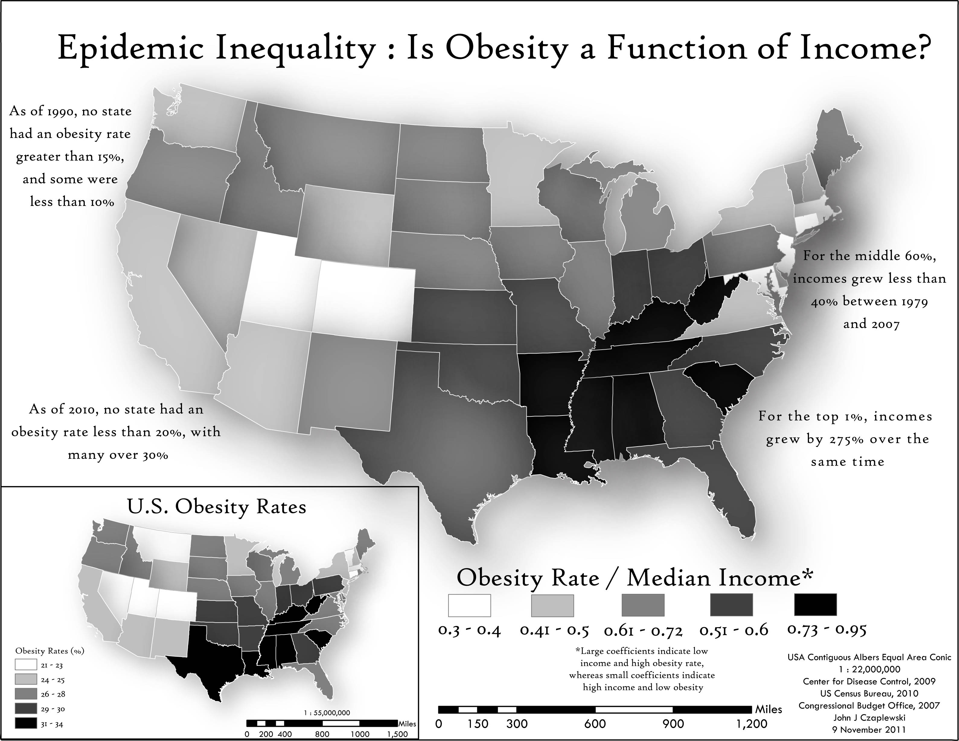
Print map of obesity rates in the US. Lab assignment in persuassive mapping.

Publications / Presentations / Abstracts / Blogs / Other

Extending the Reach and Resolution of the Paleobiology Database with Computational and Data Infrastructures

Peters, S.E., Syverson, V.J.P., Zaffos, A., Husson, J., Ross, I., Czaplewski, J.J.

GSA, October 2017

A New Tool for Deep-Down Data Mining

Shanan E. Peters, Ian Ross, John Czaplewski, Aimee Glassel, Jon Husson, Valerie Syverson, Andrew Zaffos, and Miron Livny

Earth & Space Science News, September 2017

Leveraging Geologic Maps in a Multi-Scale Interactive Environment

Czaplewski, J.J., Peters, S.E.

Digital Mapping Techniques, May 2017

Macrostrat and GeoDeepDive: A Platform for Geological Data Integration and Deep-Time Research

Peters, S.E., Husson, J., Ross, I., Czaplewski, J.J.

AGU, December 2016

Using Mobile Technology to Broaden the Impact of Academic Research

Katie Ginder-Vogel

Ionic Blog, October 2016

Wisconsin-Made App Helps Us Rock (And Know What Rocks We're Looking At)

Rob Ferrett

Wisconsin Public Radio, October 2016

GeoDeepDive: A digital library and infrastructure to support text and data mining

Peters, S.E., Czaplewski, J.J., Livny, M., Ross, I.

EarthCube Webinar, June 2016

Party with PostGIS

John J Czaplewski

UW Cartography Lab Education Series, June 2016

GeoDeepDive: A Cyberinfrastructure to Support Text and Data Mining

Ross, I., Livny, M., Theisen, T., Peters, S.E., Czaplewski, J.J.

HTCondor Week, May 2016

Going Global — Part II

John J Czaplewski

Medium, April 2016

Going Global — Part I

John J Czaplewski

Medium, April 2016

Maptime Madison studies, teaches modern mapmaking technology

Laurel White

The Capital Times, November 2015

Data Acquisition

John Czaplewski

Maptime Madison, November 2015

TopoJSON Server API in the Browser

John Czaplewski

Medium, October 2015

Macro Tiles

John Czaplewski

Medium, October 2015

Macrostrat: Towards a Common Data Infrastructure to Support Deep Time Earth Systems Science

Shanan E. Peters, Jon Husson, John Czaplewski and Andrew Zaffos

GSA North Central 2015

Macrostratigraphic Constraints on the Global Carbon Cycle

Jon Husson, Shanan E. Peters and John Czaplewski

GSA North Central 2015

A Comparative Estimate of Different Biodiversity Curves and Comments on the Link Between Rock Availability and Biodiversity

Andrew Zaffos, Shanan E. Peters, Jon Husson and John Czaplewski

GSA North Central 2015

Sharing Data: A Guide

John Czaplewski

Wisconsin Geospatial Summit 2015

Paleogeographic Boundary Conditions For Phanerozoic Biodiversity Analysis: A Quantitative Framework

Shanan E. Peters (presenter), John Czaplewski, and Seth Finnegan

Geological Society of America Annual Conference 2014

Data -> Maps. The Good Parts.

John J Czaplewski

Mapshop 2014, University of Kentucky

Responsive Interactivity: Toward User-centered Adaptive Map Experiences

John J Czaplewski, Richard Donohue, Rashauna Mead

FOSS4G 2014

Bringing Paleontology's 'Dark Data' To Light

Shanan E. Peters (presenter), Christopher Ré, Miron Livny, Ce Czhang, Vidhya Govindaraju, Michael McClennen, John J. Czaplewski

North American Paleontological Conference 2014

Getting Started with Beauitful Soup

Vineeth G. Nair (John Czaplewski - Technical Editor)

Packt Publishing, 2014

Cyberinfrastructure for Plate Tectonic Reconstructions

Mark Turner (presenter), Michael Gurnis, John Cannon, Xiaodong Qin, Shanan E Peters, Puneet Kishor, John Czaplewski

Geological Society of America Annual Conference 2013

Résumé / Curriculum Vitae

Printable résumé [PDF]

Relevant Skills


  • Front | HTML, CSS, JavaScript, TypeScript, React, Angular, Ionic, Leaflet, Mapbox GL JS, Material UI, Webpack, D3, jQuery, Boostrap
  • Back | Node.js, npm, Python, nginx, Apache, AWS, Heroku, DigitalOcean, Grunt, Gulp, ExpressJS, Bash, API design and construction
  • Geo | PostGIS, TopoJSON, GeoJSON, Turf, Tilemill, Mapbox Studio, CartoDB, QGIS, ArcGIS, GDAL/OGR, spatial data exraction, manipulation, and tooling
  • Version | git, Github
  • Database | PostgreSQL, MySQL, MariaDB, MongoDB, ElasticSearch, Redis
  • Design | Responsive web design, mobile design, data visualization, Adobe Illustrator, Photoshop, and InDesign
  • Other | Macports, Homebrew, Ubuntu, pm2, SSH, project management, systems thinking

Work Experience


Gaia GPS

Senior Software Enginneer / Manager — February 2019 to Present

  • Work with other engieners and designers to build and support a web map used by half a million unique visitors each month
  • Design, build, and maintain infrastructure for processing OpenStreetMap and satellite imagery
  • Act as technical lead for the web platform
  • Help manage AWS infrastructure for the company at large
  • Implement OAuth server
  • Manage and mentor a team of five software engineers
  • Helped triple the revenue and headcount in two years

UW-Madison Department of Geoscience

Programmer Analyst — May 2013 to February 2019

  • Direct, design, build, and implement full-stack web applications, including database design, API authoring, and front-end development
  • Lead developer for two NSF-sponsored grants
  • Create, maintain, and test open source tools and utilities to enable scientific research
  • Hire and direct student web developers
  • Visualize spatial and non-spatial scientific data for a variety of audiences

National Center for Freight Infrastructure Research & Education (CFIRE)

Spatial IT Research Intern — October 2012 to April 2013

  • Design, code, and implement interactive maps and data visualizations with Leaflet and D3
  • Create automated data collection scripts with Python
  • Stay up-to-date on current web technologies
  • Design MySQL databases and access methods
  • General design and cartographic work

Wisconsin State Cartographer’s Office

GIS/Web Support Technician — November 2011 to January 2013

  • Maintain online PostGIS databases and custom web mapping applications
  • Thoroughly document procedures and metadata
  • Troubleshoot database and application issues
  • Design and build Pronounce Wisconsin - involved researching data for an original data layer, prototyping various web technologies, and designing a user interface.
  • Support various long term projects and publications
  • Assist in writing technical papers

Education


University of Wisconsin-Madison

  • Graduate Certificate in GIS, December 2012
  • Bachelor of Arts in Political Science, May 2011

Leadership


Hoofer Council

Renovations Chair — 2010-2011

  • Collaborate with architects and Union directors on a $52 million State of Wisconsin building project
  • Represent the interests of 2,100 people and a $1.2 million dollar budget during renovation of Memorial Union and the opening of Union South
  • Chair a student committee and use creative problem solving and teamwork to reconcile differences between members and clubs

Union South Climbing Wall Committee

Chair — 2010-2011

  • Draft an operating procedure, marketing plan, and programming for the centerpiece of the new Union
  • Devise an agenda and manage weekly meetings for a committee comprised of both Wisconsin Union directors and student leaders

Hoofer Mountaineering Club

President — 2009-2010

  • Chair meetings of a 160-member club and act as a liaison to other clubs and the University
  • Collaborate with others to develop and run events for the club
  • Meet, and critically discuss with, contractors and Union representatives

Volunteering


Hoofer Mountaineering Club

Technology Chair — 2012-2013

  • Completely redesign club website
  • Documented redesign and migration process
  • Reorganize website structure into new menus for more efficient and intuitive navigation
  • Train club members to use the new WordPress CMS to update content

Devil's Lake Century Climbing Challenge

2012

  • Designed a WordPress blog to keep information about the fundraiser organized, as well as a poster [PDF] to be posted at local businesses to advertise the event.

UW Student Legal Services

  • Assist members of the University and greater Madison community with legal issues by researching Wisconsin and federal statutes, and summarizing the findings.

Honors


  • NACIS Student Travel Grant Recipient, September 2012
  • Wisconsin Union Leadership Award, April 2011
  • Deans List, Fall 2007